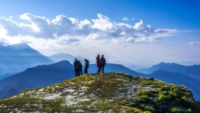
Why Everyone Needs to do a Kedarkantha Trek in Their Life?

Overview
Kedarkantha is such a famous tourist trek that it could be dubbed the “Queen of Winter Treks.” It is popular among trekkers because of the knee-deep snow in the winter, the breathtaking view from the top, as well as the wonderful and simple trails. The ‘easy on endurance’ trail winds through Govind National Park’s dense pine forests. The views from the top are worth the 12,500-foot elevation gain.
The Kedarkantha trek will provide you with an unforgettable view of the cosmic sky, vibrant meadows, ice paths, enchanting villages, fragrant pine forest, sky-scraping peaks, tranquil rivers, and mythological stories.
Some facts
- Start Point – Sankri Village
- Duration – 6 days
- Distance – 20 km
- Altitude – 12,500 ft
- Difficulty – Easy to moderate
Best time to visit
The Kedarkantha trek is among the few treks in the Indian Himalayas that can be done throughout the year. Except for July and August, the Kedarkantha trek is open for 10 months of the year (the peak rainy months in Uttarakhand).
The ten months cover four distinct seasons:
- Winter lasts from December to February.
- March and April are the months of spring.
- Summer months are May and June.
- Autumn lasts from the middle of September to the end of November
How to reach
Airways
Domestic flights from major Indian cities arrive at Jolly Grant Airport in Dehradun on a regular basis.
Railways
The nearest railway station is in Dehradun, which is well connected to major cities throughout India.
Roadways
Dehradun is well-served by a well-developed road network. You can either drive to Dehradun or take a cab/taxi from Delhi or another nearby city. Regular bus services to and from Dehradun are also available, thanks to an excellent road network.
Things to carry
- Appropriate shoes- The trek distance is long and you will need to walk for long distances , so make sure to bring comfortable trekking shoes.
- A sturdy backpack- A backpack with strong straps and a sturdy frame . A rain cover for your backpack is highly recommended.
- Additional trek pants- The trip should only require one pair of pants. However, you should keep a spare pair on hand in case the 1st one gets dirty. Wear one and keep the other pair in your bag. Denims , leggings and shorts are not recommended for hiking.
- At least 2 t-shirts- Carry light, full-sleeved t-shirts to protect your neck and arms from sunburn. Trekkers frequently make the mistake of not changing their t-shirts frequently enough. Regardless of how cold it is, the body sweats profusely. Trekkers who do not change into fresh clothes after arriving at the campsite become ill as a result of their wet clothes and are frequently unable to complete their trek.
- Thermals (optional)- Carry thermals for night time because the temperature drops dramatically and can get very chilly at the top.
- Others- Sunglasses, Sun Cap, Woollen Gloves, Socks , LED torch, Toiletries , Water Bottles and a mandatory personal medical kit.
Reasons to do
The forests
This sense of oneness with your surroundings is enhanced when you are in the forests of Kedarkantha, particularly the stretch from Gaichwangaon to the summit.
Multiple routes
As a stand-alone mountain, this trek is endowed with numerous routes to the summit, each of which is distinct and beautiful in its own right. This allows everyone to explore the trek in whatever way they want – taking the popular route or a quieter trail, adjusting the route based on the weather, and so on.
Mesmerizing sunsets
Because of the location of the campsites, this trek offers some of the most dramatic sunsets. Julota and Pukhrola are both open to the sky and face the western side of the sky. As a result, the sunsets along this trail are a must-see on the journey.
The summit
The trek is well-known for its summit, and rightly so. Firstly, this is a proper summit with a cairn. Kedarkantha is one of two summit treks in the Himalayas at 12,500 feet. The remaining shots are mostly passes or high points on a range.
This in itself is unique. The second point to mention is the route to the summit. The summit is directly ahead of you once you’ve cleared the tree line. So, from the start of the trek, you know where you’re going, and it creates an instant sense of aspiration. This increases the difficulty of the trek from the start of the summit.


